NavigationPLANNER 7/7+ Free Trial
New Navionics security update
Download NavigationPLANNER 7.26 here:
www.xnav.eu
FREE TEN DAY TRIAL at
www.navigationplanner.com/ST101
(Have your Navionics chart ready)
NavigationPlanner is the only PC Program specifically designed for marine planning with Navionics charts.
Plan with your PC at home, on board or in the office, transfer routes and waypoints to your chart plotter.
Install on three computers
NavigationPlanner allows you to back up all your waypoints and routes on your PC, import data from other sources and transfer them to your plotter.
Instructions for converting Garmin data can be found
here
Notes:
With increasing volumes of data added to charts by Navionics there are occasional instances of a small areas of loss of detail. If this is observed, it can be solved by identifying a chart listed on the Open Chart dialogue that is not needed on the intended passage. Using File Explorer (look for ProgramData) and moving the file to a temporary location (it can be put back later) usually enables the remaining chart files to be displayed in detail.
To purchase see your local dealer or contact Navionics UK
tel. 01752 258726
email. sales@navionics.co.uk
Runs on any version of Windows from XP onwards or use on a Mac with Parallels desktop, Virtual PC or VMWARE Fusion
New NavigationPLANNER 7 now:
- displays Navionics Platinum Chart Satellite overlays
- calculates course to steer using embedded tides in Navionics charts
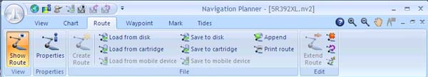
- displays bearing and distance for each leg of route
- distance and bearing to cursor permanently displayed
- total route distance shown on status bar when creating routes
- supports Navionics Sonar charts
- multiple routes can be displayed
- route library with facility to display all routes
- automatic resizing of data fields
- latest Magnetic variation data included
Also:
- Works with Windows XP, Vista and Windows 7 and 8 (32 and 64 bit) - NOT 8 RT - and tested with Apple computers using Parallels Desktop for Mac and VM Ware Fusion v2.00
- New Ribbon user interface to improve ease of use
- View Navionics charts on your PC with facilities to switch on and off layers of information
- Easy chart manipulation with a simple drag facility and if you have a wheel mouse, the wheel is used to easily zoom in and out.
- Shows charts in US symbology and colours OR international symbols
- Works with Navionics Silver, Gold, Platinum, Platinum plus, Hot Maps etc.
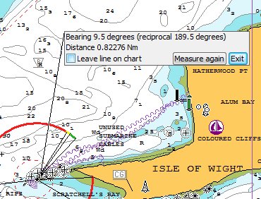
- Measure distance and bearings on the charts. NEW - Leave distance and Bearing lines on the chart and measure again.
- Set units for Speed, Distance, Fuel flow, depths etc.
- Load, create and save waypoints and routes to and from many compatible Navionics plotters via a CF, MMC, or SD media cartridge.
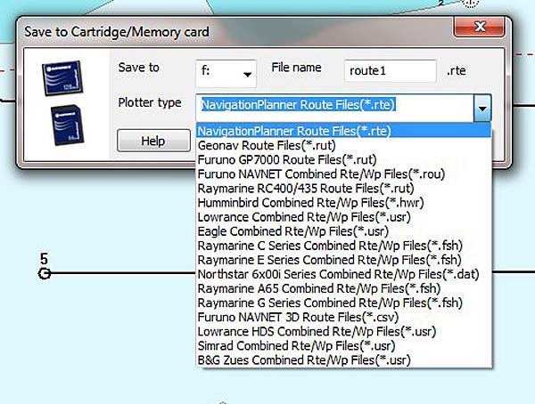
- Supports chart plotters from: B&G, Eagle, Furuno, GeoNav, Humminbird, Lowrance, Northstar, Raymarine and Simrad.
- Easy route creation by simply clicking on the chart (and near waypoints to add them to the route).
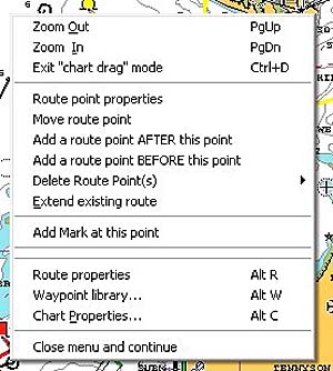
- Sophisticated route editing facilities:-
- move, delete and add individual route points
- delete multiple route points (i.e. all route points from a given point to the end of the route)
- reverse routes | extend routes | append one route to another
- copy route points to the waypoint library.
- Sophisticated waypoint editing facilities:-
- adding notes to waypoints
- add range rings to waypoints
- waypoint positions can be entered and edited in many formats.
- creating waypoints from other waypoints
- creating waypoints by applying a range and bearing from an existing waypoint
- grouping of waypoints
- editing selected or groups of waypoints at the same time
- selecting single or multiple waypoints for deletion
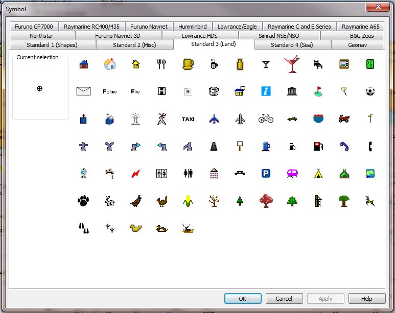
- selecting icons for the waypoints to be the same symbols as your on-board Navionics plotter (see list below for a list of compatible plotters)
- import and export from a spreadsheet
- importing waypoints from the GPS Utility which allows conversion from Garmin and C-Map plotters.
- import Garmin POI files downloaded from the web.
- Calculates elapsed times and fuel usage for routes.
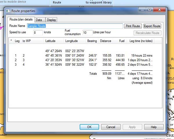
- Print full details of your routes and waypoints.
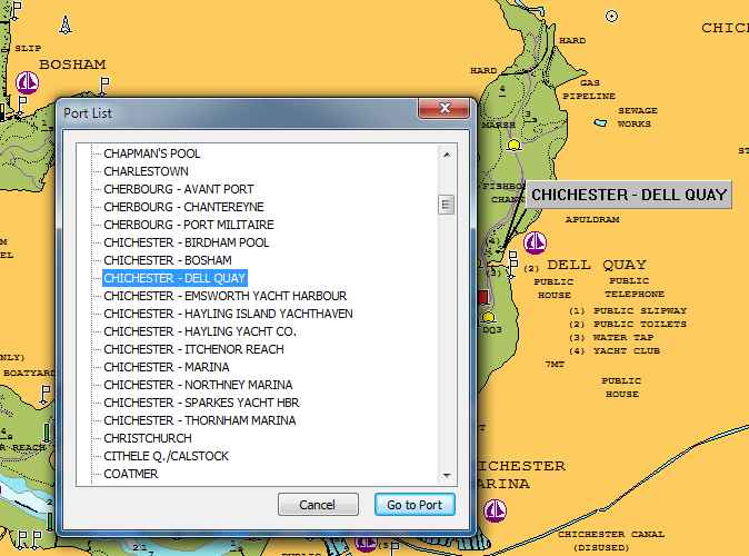
- From port lists included on the charts, locate the port with the Go-To feature.
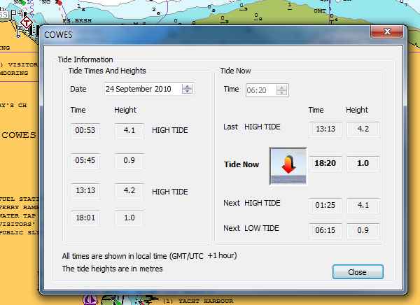
- Show tide heights and times for a port as well as sun and moon rise times.
- Show tidal flow direction and speed on the chart.
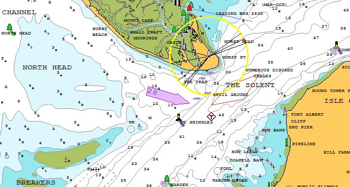
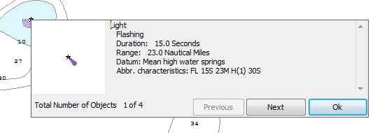
- Full chart object descriptions like buoy light sequences etc. available on right click.
- Can be configured to work in English, French, German, Italian and Dutch.
- Can be upgraded to the full chart plotting program PC Plotter (interfacing with GPS, AIS, radar etc.)
To purchase see your local dealer or contact Navionics UK
tel. 01752 258726
email. sales@navimaps.co.uk