PCPLOTTER 7 - Download now!
PCPLOTTER 7 is now available for download - start now!
View the latest Platinum+ Relief Shading on PCPLOTTER and NavigationPLANNER
Trade in your Navionics+ chart for a Platinum+ chart at half price
Purchase version 7 now and get a free upgrade to version 8 when it is released - expected at the end of 2019
Install PC Plotter on your laptop together with a Navionics chart and a GPS antenna and you have a first class chart plotter. Latest version shows satellite overlays in Navionics Platinum charts.
PCPLOTTER 7 Latest full version of PCPLOTTER available by download and online activation on three computers - giving you the option of using it for planning on your PC at home and also on an onboard PC without the need for a USB harware security key. Simply save PC Plotter and your Navionics chart (2011 onwards) to your hard drives and then use them as you need them. If you have used the three activations and change your PC we can (for a small fee) uninstall it from one machine online and unlock it on the replacement PC.
See these videos for more information concerning NavigationPLANNER and PCPLOTTER
Notes:
With increasing volumes of data added to charts by Navionics there are occasional instances of a small areas of loss of detail. If this is observed, it can be solved by identifying a chart listed on the Open Chart dialogue that is not needed on the intended passage. Using File Explorer (look for ProgramData) and moving the file to a temporary location (it can be put back later) usually enables the remaining chart files to be displayed in detail.
Look for version 2.28, due out soon, which has solution for this issue.
1. Saving and loading charts2. Using Navionics charts 3. Viewing tides4. Creating a route5. Course to steer and optimum departure time6. Transferring routes to chartplotter
£150.00 for download versionSee how you can use PCPLOTTER here:
Using Navionics charts Creating a routeLatest version can show satellite overlays in Navionics Platinum charts.
Plan your cruise at home using PC Plotter:
Plot your waypoints and determine the optimum time to leave port using tidal information in the chart.
PC Plotter has all the planning facilities of NavigationPLANNER 7 together and also includes the following:
- quick Go To routing facility
- click near an existing waypoint to add it to a route
- right click a waypoint and drag it to another position
- PC Plotter calculates the bearing, distance and course to steer for each leg
- Zoom in and out from the chart
- find your boat on the chart or zoom to it at the touch of a button
- create your own marks and build your own database
- input NMEA data from your instruments and display instrument data - choose your own instrument format
- draw bearing lines on the chart to aid your navigation
- download and overlay weather information from your chosen data source
Runs on any version of Windows from XP onwards or use on a Mac with Parallels desktop, Virtual PC or VMWARE Fusion.
PCPlotter can be used with both the latest Navionics charts and also earlier versions.
Navigation Software
Got a new plotter? - Old waypoints in the wrong format?
Let us try reformatting them using NavigationPLANNER so that you can use them in the new plotter
Free up to 250 points!
Contact us.
Garmin ADM format waypoints can now be downloaded into NavigationPLANNER and PCPLOTTER
Navigation Planner version and PC Plotter now version 7.21
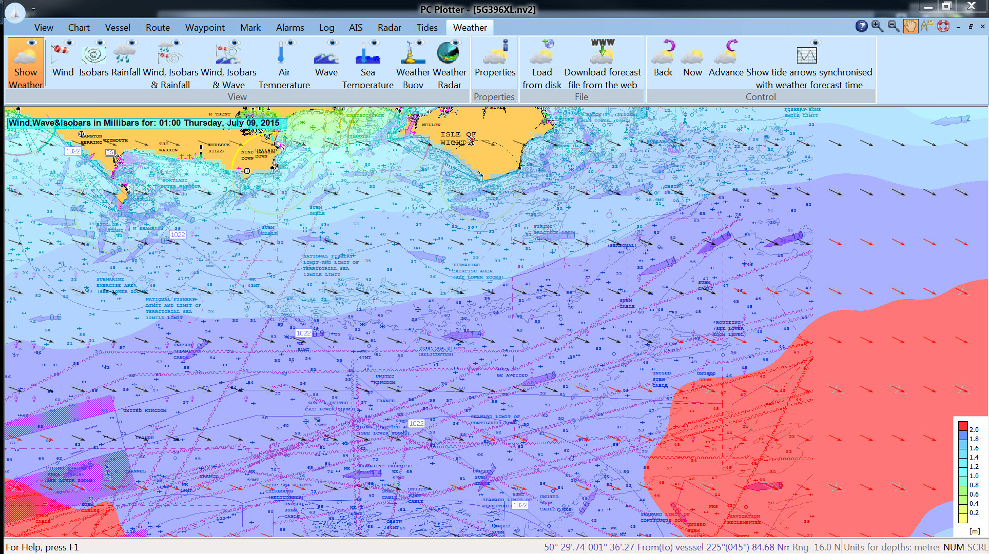
NEW - Set a maximum wind speed and wave height and see values equal or greater than emphasised in red as you step through a downloaded Theyr forecast - see a demo here.
The wave height layer is semi transparent and its possible to view synchronised tide arrows as you move through the forecast.
 NavigationPLANNER 7 and NavigationPLANNER+ planning software use an interface based on Windows. The latest version of this great cruise planning tool calculates optimum route times based on tidal data within Navionics charts and gives course to steer before you set off.
Plan your cruise at home and then upload the data to your chart plotter* when you get onboard.
Developed by yachtsmen over many years NavigationPLANNER 7 is an extremely stable cruise planning program.
NavigationPLANNER+ has all the features of NavigationPLANNER together with the facility to show the position of the vessel on the chart when a suitable GPS unit is attached.
To purchase see your local dealer or contact Navionics UK
tel. 01752 258726
email. sales@navionics.co.ukTRY A TEN DAY FREE TRIAL www.navigationplanner.com/ST101
Please ensure that you have your Navionics chart before starting
 Download and start using with your Navionics card now!
PCPlotter navigation software uses an interface based on Windows. It has all the planning features of NavigationPLANNER together with dynamic course management to give a full featured navigation system for the cruising yachtsman.
Download a PC Plotter demonstration program
here (Unzip and run the Setup.exe file)
PC Plotter 7.27 - Download and start using - £150
£150.00
in stock
More info